Hurricane Francine Update for the Alabama Gulf Coast
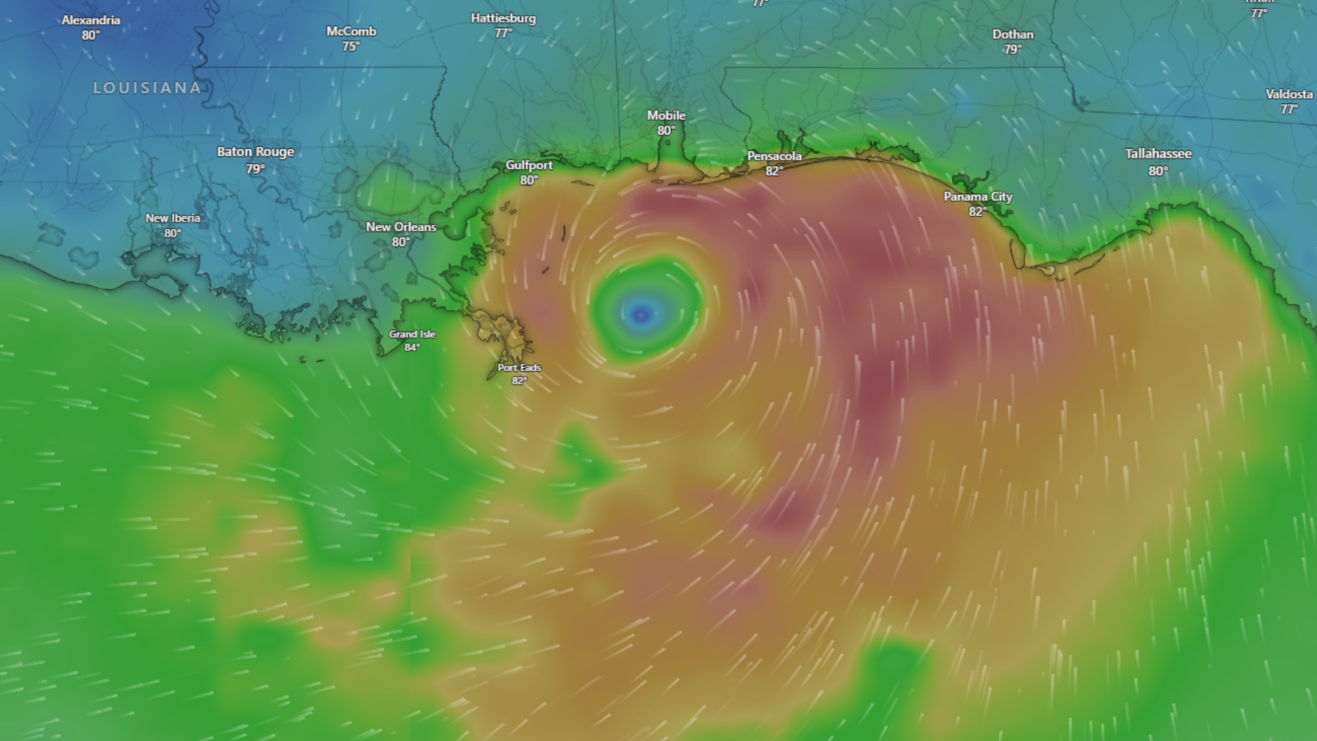
Hurricane Francine has made landfall near Morgan City, LA.
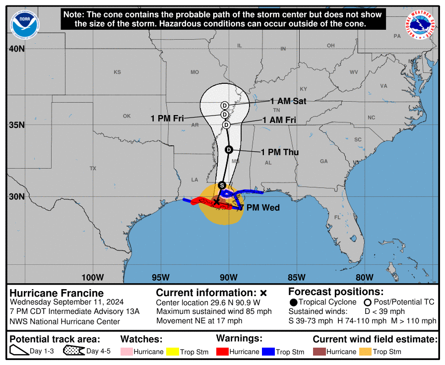
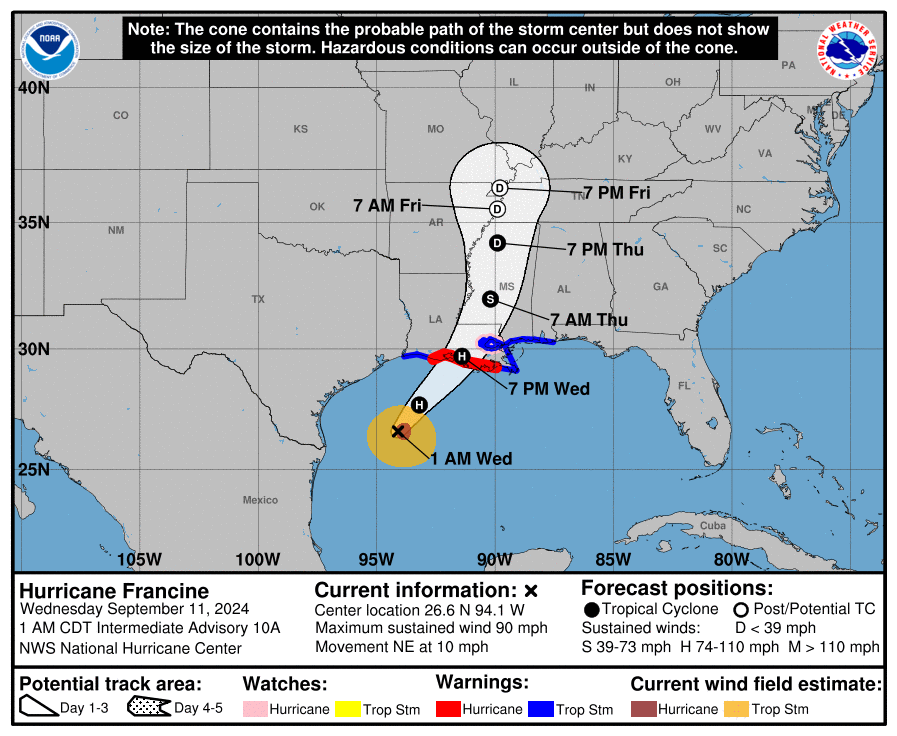
FINAL Update at 7:00pm: As of the 7pm update on Wednesday, September 11th, Hurricane Francine has made landfall near Morgan City, LA. Winds have diminished to 85mph. The forecast track has remained steady since the 10am update on Tuesday. It is moving to the northeast at 17 mph.
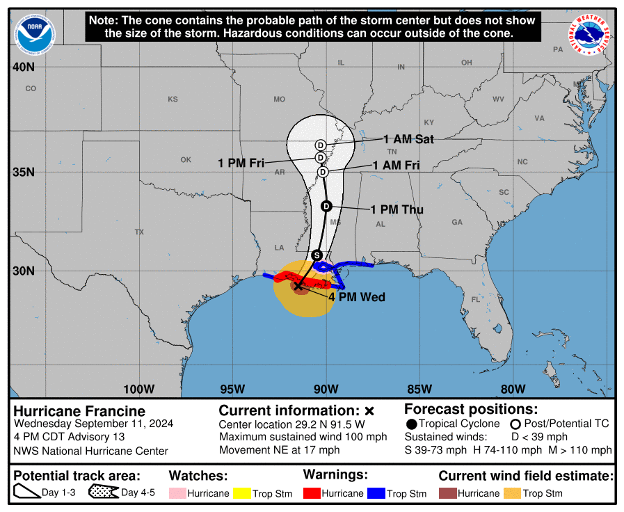
Update at 4:00pm: As of the 4pm update on Wednesday, September 11th, Hurricane Francine’s winds are now at 100mph. The forecast track has remained steady since the 10am update on Tuesday. Landfall is forecast to take place around 7pm near Morgan City, Louisiana with winds around 100mph. Hurricane Francine is now moving at 17mph to the Northeast.
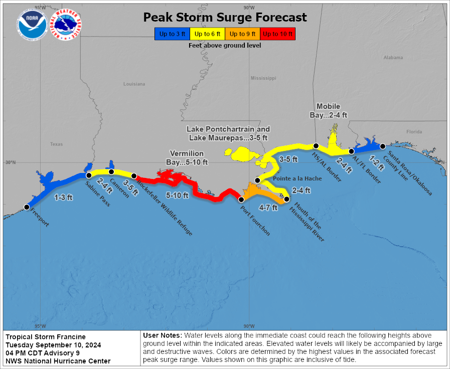
No changes in the forecast for the Alabama Gulf Coast since Tuesday’s 10am forecast. We are still under a Tropical Storm Warning with a forecasted surge of 2–4 feet.
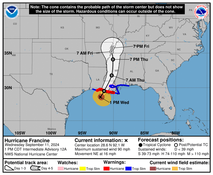
Update at 1:00pm: As of the 1pm update on Wednesday, September 11th, Hurricane Francine’s winds are still at 90mph. The forecast track has remained steady since the 10am update on Tuesday. Landfall is forecast around 7pm near Morgan City, Louisiana with winds around 90mph. Hurricane Francine is now moving at 16mph to the Northeast.
No changes in the forecast for the Alabama Gulf Coast since Tuesday’s 10am forecast. We are still under a Tropical Storm Warning with a forecasted surge of 2–4 feet.
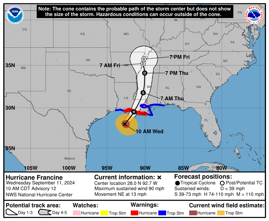
Update at 10:00am: As of the 10am update on Wednesday, September 11th, Hurricane Francine’s winds are still at 90mph. The forecast track has remained steady since the 10am update on Tuesday. Landfall is still expected this afternoon with the center line of the forecast traveling just west of New Orleans. Hurricane Francine is now moving at 13mph to the Northeast.
No changes in the forecast for the Alabama Gulf Coast since Tuesday’s 10am forecast. We are still under a Tropical Storm Warning with a forecasted surge of 2–4 feet.
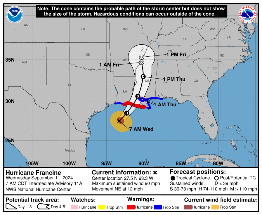
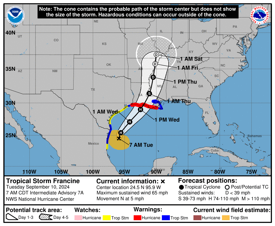
Update at 7:00am: As of the 7am update on Wednesday, September 11th, Hurricane Francine’s winds are still at 90mph. The forecast track has remained steady since the 10am update on Tuesday. Landfall is still expected this afternoon with the center line of the forecast traveling just west of New Orleans and just east of Baton Rouge. Hurricane Francine is now moving at 12mph to the Northeast.
No changes in the forecast for the Alabama Gulf Coast since Tuesday’s 10am forecast. We are still under a Tropical Storm Warning with a forecasted surge of 2–4 feet.
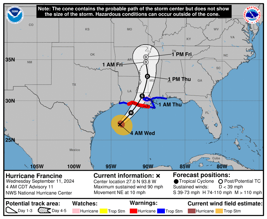
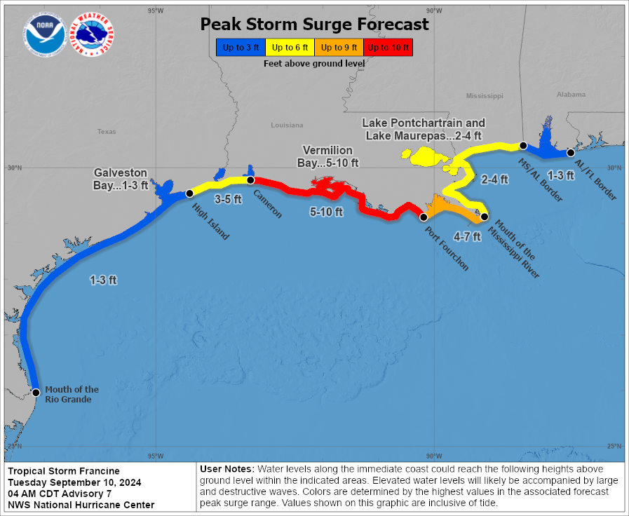
Update at 4:00am: As of the 4am update on September 11th, Hurricane Francine’s winds are still at 90mph. The forecast track has remained steady since the 10am update on Tuesday. Landfall is still expected just to the west of New Orleans. Hurricane Francine is still moving at 10mph to the Northeast.
No changes in the forecast for the Alabama Gulf Coast.
Update at 1:00am: As of the 1am update, Hurricane Francine now has sustained winds at 90mph. The forecast track has remained steady since the 10am update Tuesday morning. Landfall is still expected to be just west of New Orleans. Hurricane Francine is maintaining its speed and direction at 10mph to the Northeast.
No changes in the forecast for the Alabama Gulf Coast.
Update at 10:00pm: As of the 10pm update, Hurricane Francine still has sustained winds of 75mph and is still tracking to the Northeast at 10mph. The forecast track has remained steady since the 10am update, showing it making landfall west of New Orleans.
No changes in the forecast for the Alabama Gulf Coast.
Update at 7:00pm: As of the 7pm update, Francine is now a Hurricane with sustained winds of 75mph. The forecast track has remained steady since the 10am update, showing it making landfall west of New Orleans. Hurricane Francine is still moving at 10mph to the Northeast.
No changes in the forecast for the Alabama Gulf Coast.

Update at 4:00pm: As of the 4pm update from the National Hurricane Center, Francis is still a tropical storm with 65 mph winds. It has picked up to 10 mph in movement to the Northeast.
The forecast track hasn’t changed since the 10am update, but the Alabama Gulf Coast has gone from being under a Tropical Storm Watch to a Tropical Storm Warning. A Tropical Storm Watch is issued when tropical storm conditions, such as sustained winds of 39 to 73 mph, are possible within a designated area, usually within 48 hours. It signals that residents should prepare and stay informed. A Tropical Storm Warning, on the other hand, is issued when such conditions are expected within 36 hours, indicating that the threat is imminent, and precautionary measures should be completed.
We are still forecast to see a 2-4 foot surge.
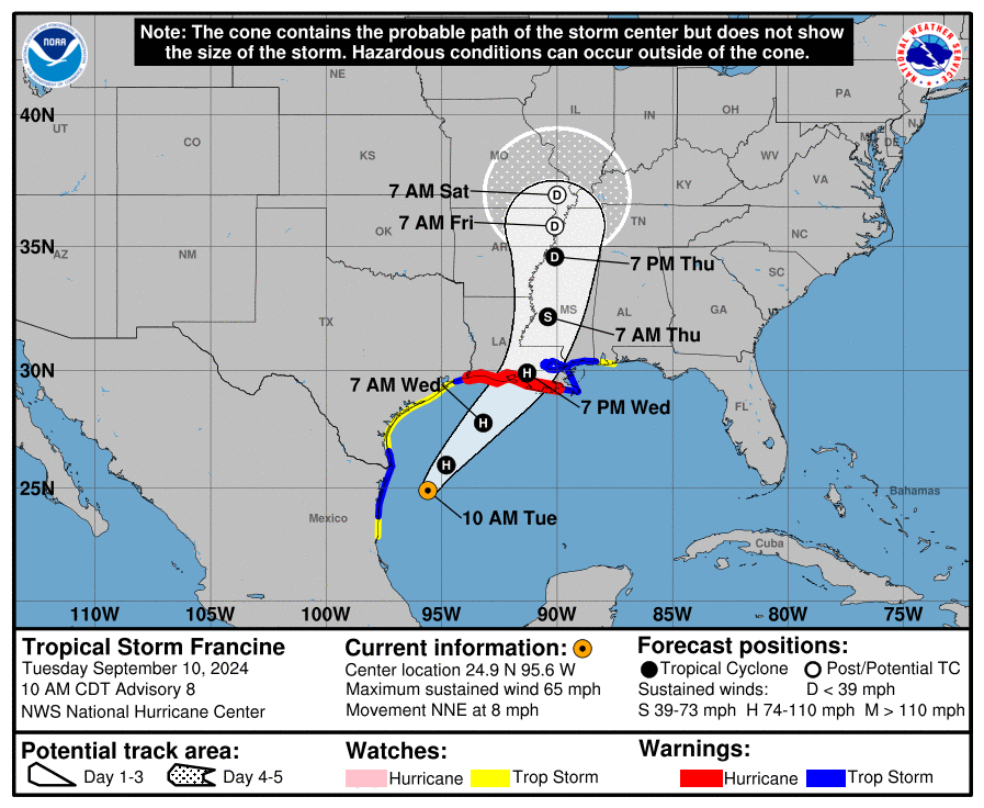
Update at 10:00am: As of the 10am update from the National Hurricane center Francine is still a tropical storm with 65 mph winds, traveling NNE at 8 mph. The forecast track has shifted a little further east from previous forecasts. If this forecast track holds true, New Orleans will feel more of the effects of Hurricane Francine.
The slight shift to the east in the forecast track has put the Alabama Gulf Coast under a Tropical Storm Watch and it has increased our forecasted surge to 2–4 feet.
Original Article:
Orange Beach, Ala. – (OBA) – T.S. Francine is forecast to become a Hurricane later this morning. The 7am advisory has Francine’s maximum winds at 65 mph and it’s moving at 5 mph to the north. The Francine is forecast to make landfall as a Cat.2 hurricane between New Orleans and Lake Charles, Louisiana on Wednesday morning.
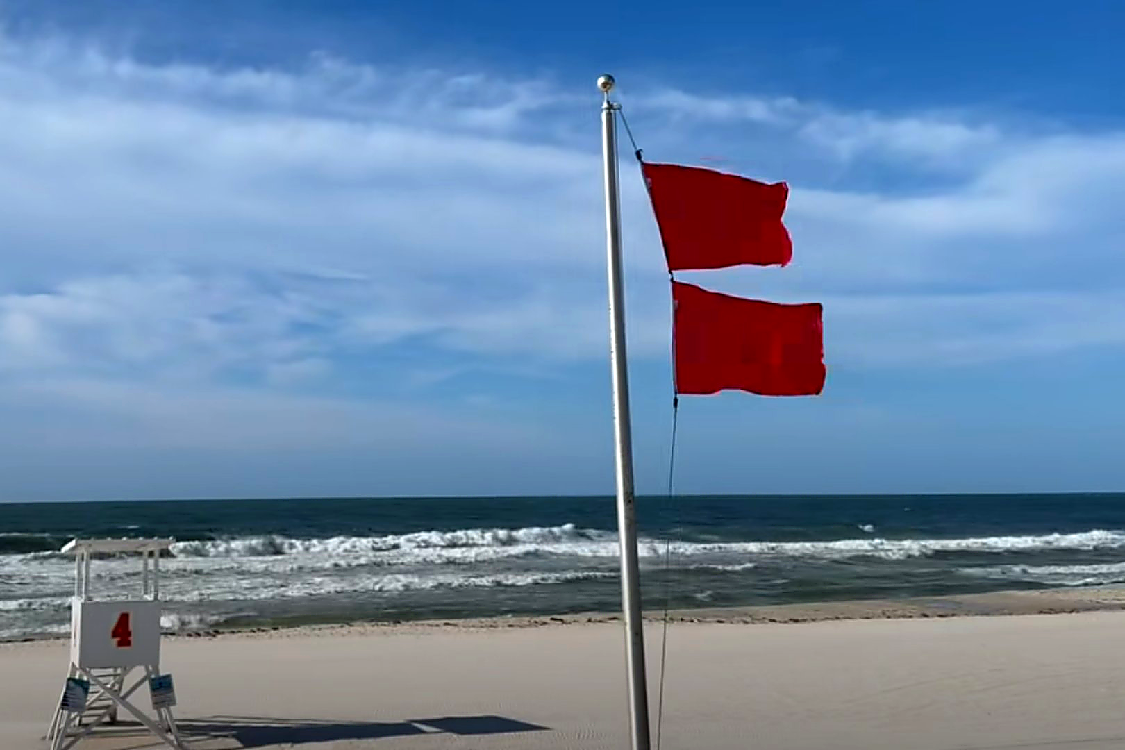
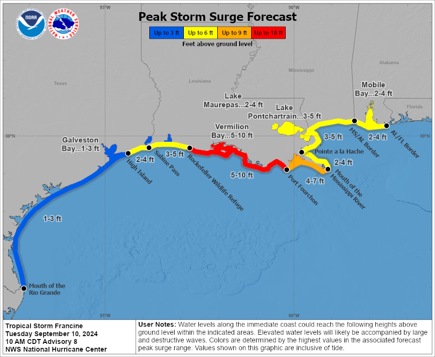
The primary impacts for our area will be strong rip currents, high surf, marine advisories. Depending on what the rain bands do, we could see potentially heavy rain, minor coastal flooding, gusty winds, and the potential for waterspouts along the coast and tornadoes inland. We are expected to have a 1-3 foot storm surge from Francine.
Bullet Points:
- High risk of rip currents Tuesday through Friday night
- High surf advisory Wednesday through Thursday night
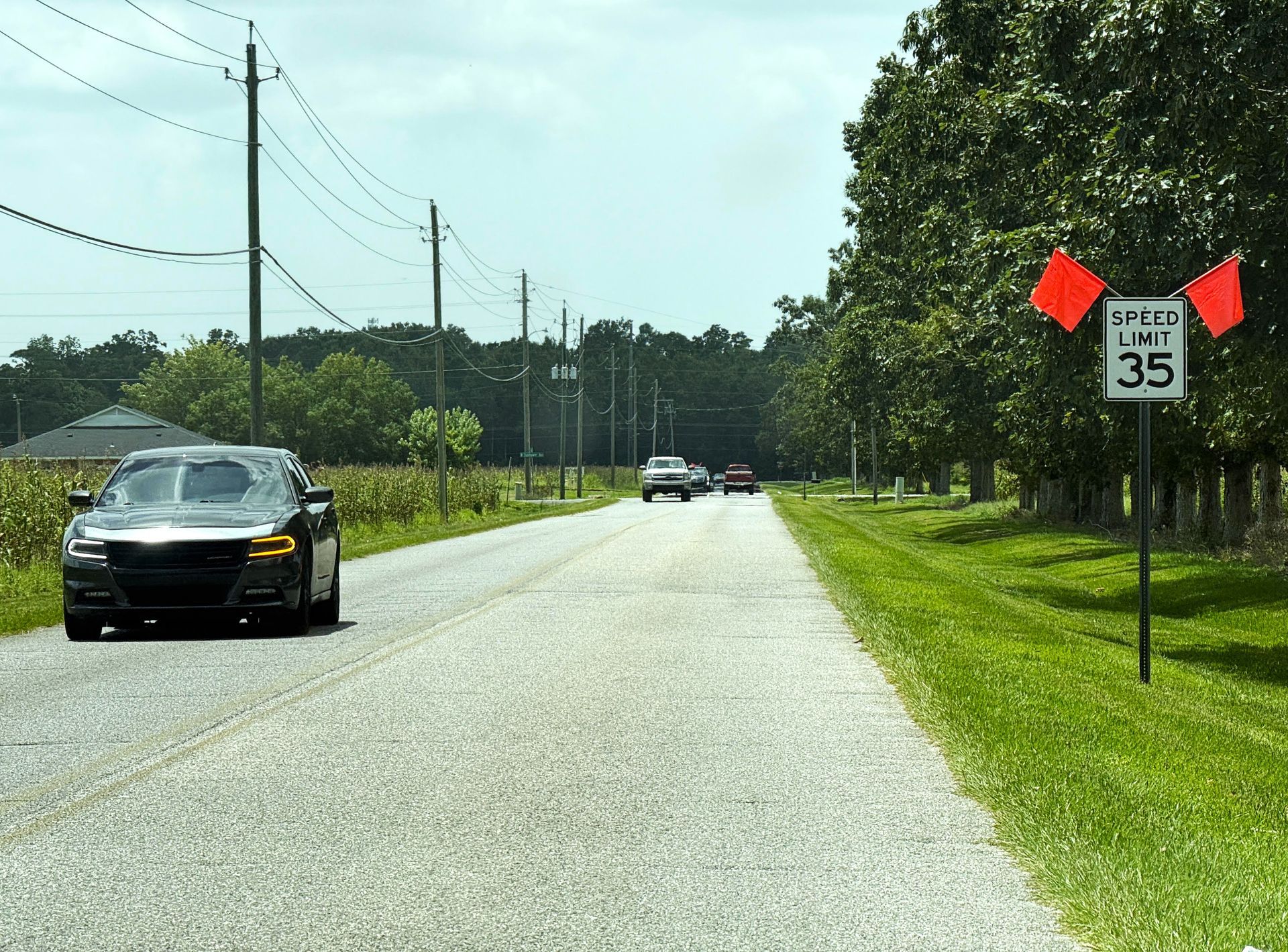
- Minor coastal flooding in coastal Alabama Wednesday into Thursday
- Locally heavy rains and potential for localized flash flooding from Wednesday into Thursday
- Isolated tornadoes are possible from Wednesday into Thursday
Webpages for Weather:
Be Prepared:
Hurricane Francine serves as a good reminder for residents along the Alabama Gulf Coast to stay vigilant and prepared during hurricane season. Even when a storm seems distant, the unpredictable nature of hurricanes can lead to sudden changes in intensity or direction, as seen in past storms, like Hurricane Sally. Preparedness is key to minimizing damage and ensuring the safety of you and your family.
Here are some important steps to take in preparation for hurricane season:
- Create an emergency kit with essentials like water, non-perishable food, medications, and flashlights.
- Secure outdoor items such as patio furniture or loose debris that could become projectiles in high winds.
- Review your evacuation plan and know the evacuation routes for your area and the location of the nearest shelters.
- Stay informed by monitoring local weather updates and having battery-powered radios.
- Prepare your home when a hurricane threatens your area by boarding windows and doors, especially if you live in coastal or flood-prone areas.
- Check on Family & Friends, particularly the elderly and those with medical conditions, to ensure they have a safe evacuation plan and necessary supplies. These individuals may need extra assistance preparing for or responding to a storm.
- Check your insurance coverage to ensure you're protected against hurricane-related damages.
For more detailed information on hurricane preparedness, visit the NOAA Hurricane Preparedness website.
Share this article w/ Friends...