
NOAA Satellite Imagery after Hurricane Sally
R. Ken Cooper • September 21, 2020
Imagery from Sept. 18th, 19th & 20th can be downloaded
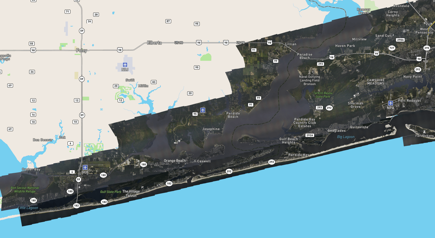
(OBA®) - NOAA has published a map with satellite images taken after Hurricane Sally came ashore on the Alabama Gulf Coast. The eye passed over Gulf Shores and Orange Beach Alabama with some of the highest winds from Fort Morgan Alabama to Perdido Key Florida.
Some of the worst damages took place just north of the coast from all of the trees falling. These areas include Foley, Elberta, Lillian and surrounding areas.
Some of the worst damages took place just north of the coast from all of the trees falling. These areas include Foley, Elberta, Lillian and surrounding areas.
Share this article w/ Friends...

Foley, Ala. — (OBA) — An Elberta woman has been named the American Legion Auxiliary Volunteer of the Year for the State of Alabama. Judi Wheat received the honor at a recent district meeting at American Legion Post 99 in Foley. Alabama State American Legion Auxiliary President Carla Biniecki presented the award. Famil
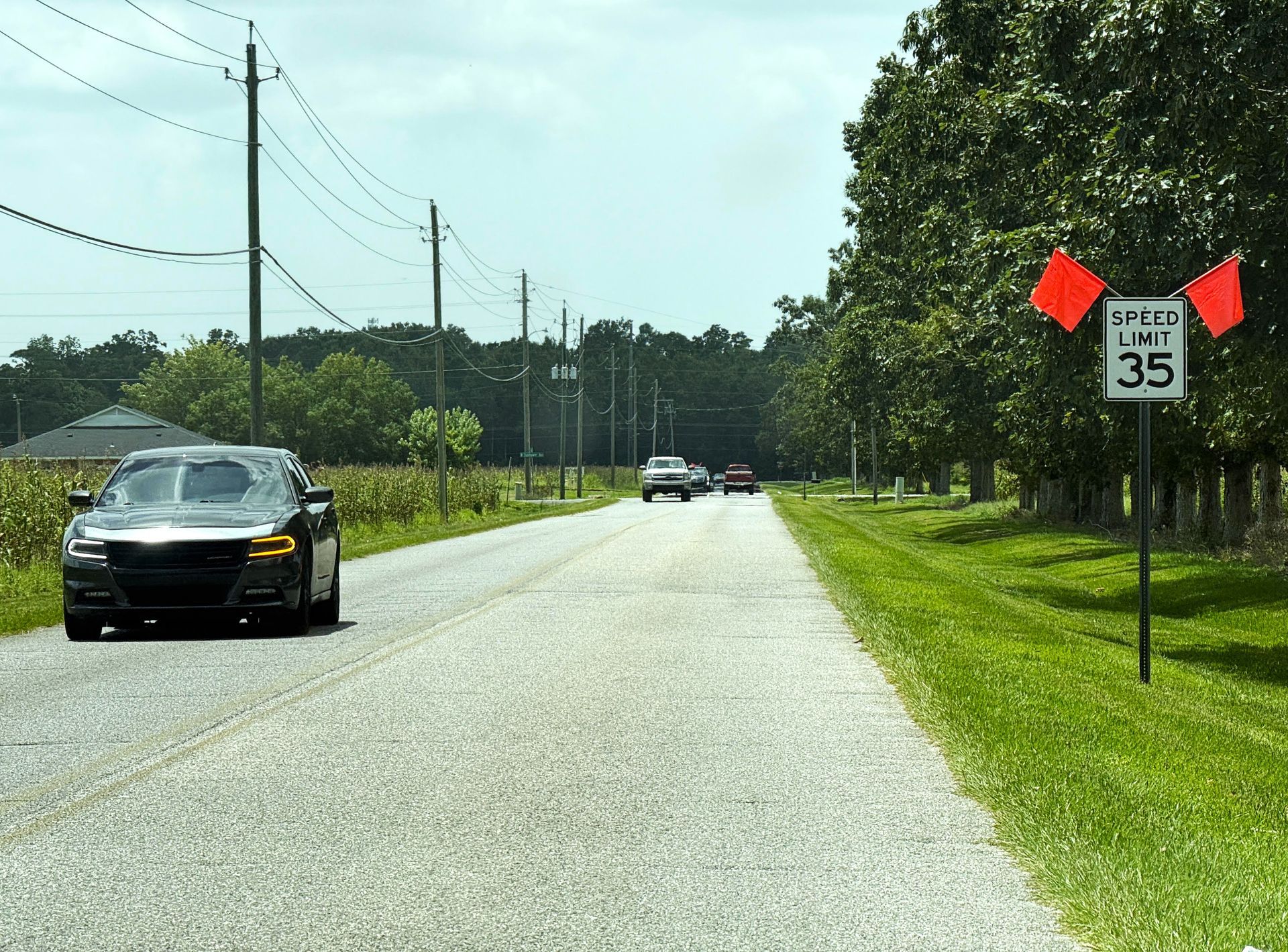
Foley, Ala. — (OBA) — The City of Foley has lowered the speed limit on Irwin Street to improve access for low-speed vehicles. The Foley City Council gave final approval to an ordinance implementing the change. The new limit is 35 miles per hour, down from 40 miles per hour. Mayor Ralph Hellmich said the lower limit wi
Orange Beach, Ala. — (OBA) — Orange Beach is taking its next step toward environmental preservation. The City Council will vote on a resolution awarding an $84,297.04 bid to Integrated Aqua Systems, Inc., for life-support equipment at the Coastal Alabama Sea Turtle Facility. This project underscores the city's commitm

Orange Beach, Ala. — (OBA) — Around here, paradise doesn't come with a one-size-fits-all itinerary — and thank goodness for that. One day, you’re chasing treasure with pirates and princesses; the next, you're cruising down Fort Morgan Road with sandy feet and nowhere particularly urgent to be. Add in a whimsical stop
Gulf Shores, Ala. — (OBA) — Gulf Shores plans to revamp its seasonal displays as the city's current holiday decorations rapidly deteriorate due to age, harsh conditions, and storage constraints. Public works officials recommend shifting from a diluted citywide approach to a concentrated, professionally managed design

Foley, Ala. — (OBA) — Foley is positioning its municipal airport for growth as city leaders prepare to advance plans for a new terminal building. The infrastructure push is the main topic in the slate of transit, drainage, and community enhancements aimed at reinforcing the city's long-term development stewardship.

Orange Beach, Ala. — (OBA) — A vessel accident near The Wharf Marina on the Intracoastal Waterway sent nine patients to area hospitals Friday evening. Multiple emergency agencies from the region responded to the scene, and the Alabama Law Enforcement Agency (ALEA) is leading ongoing operations.

Gulf Shores, Ala. — (OBA) — National Ice Cream Day, a celebration of one of America’s favorite desserts, brings a sweet seasonal tradition to the Alabama Gulf Coast, where locals and visitors alike indulge in cool treats to beat the heat. Celebrated annually on the third Sunday in July, this fun and flavorful holiday i

Orange Beach, Ala. — (OBA) — A low-pressure system over the northeastern Gulf of America is organizing and could become a tropical depression by Sunday evening or Monday, the National Hurricane Center said in its 8 a.m. EDT advisory on Sunday, July 19, 2026. The NHC placed the probability of formation at 80 percent wi

Orange Beach, Ala. — (OBA) — The American Red Cross will hold a blood drive at the Orange Beach Adult Fitness Center. The drive will be held in the facility’s training room. Donors can give blood, platelets, or AB Elite plasma. Walk-ins are welcome, though scheduled appointments will be honored first.
