
Gulf Coast Prepares For Rip Currents, Rain and Warm Temperatures This Weekend
Rain gauges have already recorded 0.23” of rain since midnight
Orange Beach, Ala. — (OBA) — Early-morning gauge readings already show 0.23 inches of rain across the Orange Beach area. Beachgoers and residents should prepare for a warm, humid stretch with passing afternoon thunderstorms. Sweltering conditions will push heat index values into the triple digits before scattered showers bring brief relief. Gusty coastal winds and shifting rain chances will keep local weather dynamic over the coming days.
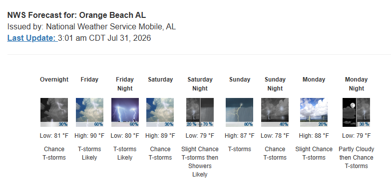
Starting today, Friday, July 31, temperatures will peak near 90°F, with heat index values soaring as high as 106°F. Rain chances increase to 60%, mainly after 4:00 PM, with west winds blowing at 10 to 15 mph. Showers and thunderstorms remain likely into Friday night before 7:00 PM, with overnight lows near 80°F and wind gusts up to 20 mph.
Saturday, August 1 offers a daytime window with only a 30% chance of showers before 4:00 PM and a high near 89°F. Overnight, the precipitation risk jumps to 70% after 1:00 AM, as lows drop to 79°F.
Sunday, August 2 has the highest likelihood of widespread rainfall, with an 80% chance of showers and thunderstorms before 1:00 PM. The high stays near 87°F. Sunday night brings lingering 40% storm chances and a low near 78°F.
Drier conditions return on Monday, August 3, bringing mostly sunny skies and a high near 88°F. Rain chances drop to 20% during the daytime hours under lighter southwest winds, before a modest 30% chance of nighttime showers returns after 1:00 AM.
Share this article w/ Friends...